


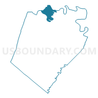
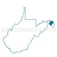
Voting District 42, Berkeley County, West Virginia
About
Outline

Summary
| Unique Area Identifier | 690345 |
| Name | Voting District 42 |
| County | Berkeley County |
| State | West Virginia |
| Area (square miles) | 8.56 |
| Land Area (square miles) | 8.56 |
| Water Area (square miles) | 0.00 |
| % of Land Area | 100.00 |
| % of Water Area | 0.00 |
| Latitude of the Internal Point | 39.58989630 |
| Longtitude of the Internal Point | -78.02875660 |
Maps

Graphs
Select a template below for downloading or customizing gragh for Voting District 42, Berkeley County, West Virginia


Neighbors
Neighoring Voting District (by Name) Neighboring Voting District on the Map
- Voting District 23, Morgan County, WV
- Voting District 40, Berkeley County, WV
- Voting District 41, Berkeley County, WV
- Voting District 44, Berkeley County, WV
- Voting District 48, Berkeley County, WV
- Washington Precinct 15-001, Washington County, MD
Top 10 Neighboring County Subdivision (by Population) Neighboring County Subdivision on the Map
- Valley district, Berkeley County, WV (21,229)
- Norborne district, Berkeley County, WV (10,965)
- District 3, Morgan County, WV (6,200)
- District 15, Indian Spring, Washington County, MD (2,019)
Top 10 Neighboring Unified School District (by Population) Neighboring Unified School District on the Map
- Washington County Public Schools, MD (147,430)
- Berkeley County School District, WV (104,169)
- Morgan County School District, WV (17,541)
Top 10 Neighboring State Legislative District Lower Chamber (by Population) Neighboring State Legislative District Lower Chamber on the Map
- State Legislative Subdistrict 1C, MD (39,335)
- State House District 52, WV (24,886)
- State House District 51, WV (20,765)
- State House District 54, WV (19,182)
Top 10 Neighboring State Legislative District Upper Chamber (by Population) Neighboring State Legislative District Upper Chamber on the Map
- State Senate District 16, WV (149,067)
- State Senate District 15, WV (122,121)
- State Senate District 1, MD (118,930)
Top 10 Neighboring 111th Congressional District (by Population) Neighboring 111th Congressional District on the Map
Top 10 Neighboring Census Tract (by Population) Neighboring Census Tract on the Map
- Census Tract 9712.01, Berkeley County, WV (9,837)
- Census Tract 9707, Morgan County, WV (6,355)
- Census Tract 9712.02, Berkeley County, WV (5,845)
- Census Tract 106, Washington County, MD (5,033)